For a few days after leaving Old Huanky the combination of rainy season and dirt roads began to manifest in some slightly muddy surfaces. As we manoevered our front wheels through puddles and round the brown stuff, Haz contemplated retiring from cycling, to pursue her chemistry studies. A PhD in ‘The Rheology of Mud’ briefly beckoned.
Mud
Collins’ definition :
noun a fine-grained soft wet deposit that occurs on the ground after rain, at the bottom of ponds, lakes, etc.
Extract from Wikipedia:
Clay soil can pose problems for traffic when moisture is present. A road built upon such soil may become stable over time as the packing of the soil will make it more water-resistant. However, any attempt to grade it can be disastrous, since excess water can then enter the surface and will be worked in by traffic, transforming portions of the road into a mud bog that can trap vehicles.
When we weren’t gawping at the still-spellbinding scenery, the road surfaces were keeping us entertained, or at least demanding our full attention. Climbing to Punta Caudalosa Chica we happened across the bad mud.
Bad Mud
The coagulation of dirt and gravel around the forks of one’s bicycle. In extreme cases it can prevent one from reaching Andean passes.
Easy climbing gave way to a sticky, cloggy surface which was impossible to ride. As we were only 5km and 250m from what we suspected was the highest pass of our route, we dismounted and began pushing. But within 20m our wheels were too jammed to move and our shoes had become resoled with 2kg dinner plates. Often in the past we’ve made things difficult for ourselves through pig-headedness and stubbornly refusing to turn round, but this time we knew we were beaten. We descended to some workmen (‘we told you not to go that way‘), and threw the bikes in a stream for an hour long bathing session. Then began a long detour to attack from the other side.
The following day, after hours of overnight sleet and snow, we pedalled a far muddier looking mine road. But this was good mud, and it wasn’t too much effort to slice right through it.
Good Mud
A fine watery deposit that slows one’s bicycle and covers one from head to foot, but does not prevent forward motion.
More the fool who deviated from the tyre tracks to the side verges however – the accumulation around forks would then immediately begin again.
A couple of passes and some puddle bike-washes later we descended to the Pisco-Ayacucho paving. En route the locals continued to shower us with hospitality, and the scenery to be fantastic.
Our route south from Huaraz is turning out to be an absolute classic.
(And we’re not the only ones to think so. Check out Cass and Kurt‘s recent blog posts – they’re following closely behind and both know more than most about cycling the world’s dirt roads.)
Elevation Profile
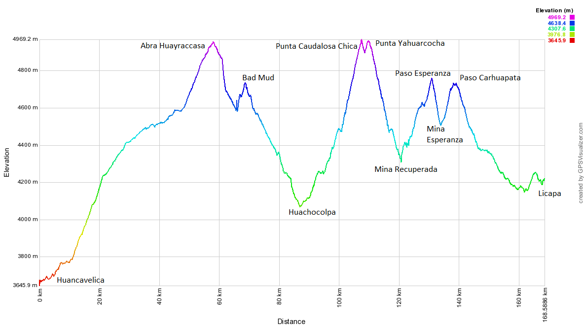
Stats – Huancavelica to Licapa
3 days
169km (54km paved)
3,470m climbed
6 x 4,000m passes (well, kind of)
6 choc bars, 700g pasta, 1.5l pop each.

- Leaving Huancavelica we have our first easy day since Huaraz. You really appreciate the speed at which you can climb on paving after a few weeks on the dirt. This being Peru, there was still plenty of ascent though – more than 1300m from town, over Abra Chonta and onwards to Abra Huayraccasa.

En route to Abra Chonta is this odd hairpin bend. We think it’s a left-over from an old railway line on which the road is built. Haz couldn’t resist returning to cycle round it. Choo choo!

At paved 4880m Abra Chonta is the turn-off for Abra Huayraccasa, only 3.5km of easy dirt climbing away. The clouds are enthralling, but soon bring snow.

The Highest Pass in the Americas! Or so most maps still claim. The sign has been repainted without the claim, but still states the altitude as 5059m. Our (and everyone else we know’s) GPS gave it as around 4975m. It briefly enters our ‘10 Highest Peruvian Passes‘ list, only to be displaced the following day…

An hour into our descent from Huayraccasa the snow arrives. We find a very unlikely picnic area, where we’re able to cook and eat in a small hut, then put up our tent a few hours later once the snow ceases. In the morning all is white as we begin the short 400m climb to Punta Caudalosa Chica. It all begins easily enough…

…until the surface turns to BAD mud.

‘Bugger’ was heard to be muttered a few times.

The wheels weren’t spinning too smoothly at this point, so we admitted defeat and turned back.

Probably didn’t do the drive chain any good on the 1km descent to a stream…

…in which the bikes were given a well needed hour of scrubbing.

Back at the main road we run into some workmen we’d chatted to the day before. ‘We told you not to go that way’ they say. And it’s true, they had. We’d assumed however that they meant the route we wanted to take was a private mine road (which it turns out it wasn’t), not that the surface was a sticky brown mess.

We resign ourselves to the 1700m descent to Lircay, where we know we can pick up a dirt road over to Licapa and the paved Pisco-Ayacucho highway. On the way we pass through the Caudalosa Chica mine. It’s more of a village/mine, with shops, restaurants and many families living there.

We’ve been surprised by how little we’ve seen in the way of mines this route – Caudalosa Chica was only the third we’ve passed close to. We quite enjoy a mine-cycle every now and then; the enormous machinery is oddly compelling. Plus they build random other massive things like this new swimming pool.

On the way to Lircay we have a stroke of luck. At the junction for Recuperada, there’s a taxi coming down from what we assumed from Google Earth was a private mine road. But the driver tells us otherwise – we’re allowed to use this road, and can get up to Punta Caudalosa Chica the back way, after a long detour. Great news! Here’s Haz at about 4900m, climbing through mud to the pass.
")
But the mud is nowhere near as bad on this side, so 6 hours later than expected we make it to the top. The GPS reads 4990m, which probably makes this the highest point of our route. Here’s Pike extracting some mud from his front brakes for the 50th time that day.
")
After a slight descent from Punta Caudalosa Chica, we can’t resist a very short detour up to Punta Yahuarcocha. On the climb, the snow eases and the sun comes out.
")
It’s a beautiful spot, particularly with the wind blowing the cloud and spray about. Our GPS says 4980m, which if accurate would mean that Abra Huayraccasa, far from being the Highest Pass in the Americas, is in fact only the third highest pass within a 10km radius.

Descending from Punta Yahuarcocha is this colourful hill. Cerro de los Siete Colores eat your heart out…

Then at 16:00 the snow we knew was coming all day, arrives. Luckily we’re near Margarita’s (L) house, and she allows us to sleep under the cover of some of her outbuildings. She’s the first person we’ve met in Peru who speaks no Spanish, so we revive our Asian-learned sign language and soon we understand one another. In the evening, and again in the morning, she plies us with food.

Her soggy and recently-shorn alpacas are a sorry looking lot as we set off late the following morning, once the sleety snow finally ends after 14 hours.

But all around these parts the hills were alive with the cheery whistling of vicuñas.

Then it’s an hour or so of climbing on GOOD mud to Paso Esperanza.

After the pass we descend to the mine, then continue climbing to Paso Carhuapata. Having been turned round after trying to enter a mine on a private road earlier in our trip, to our delight all the mine roads round here seem to be public. We’re allowed to pedal by all the excavation work as we please.

But once we leave the tracks used by the mine trucks, it turns to bad mud again. We slip and slide all over the place for a tricky km, but are able to ride it all.

Then reach a non-mine road which is in far better condition. It takes an hour to clean the bikes again, this time in a puddle, before beginning the long descent to Licapa and the paving.

On the way it chucks it down again, and the lightning and thunder crashes all around. We take refuge in a village for a while, but all the locals seem not to notice the weather. The 5-a-side football match continues in the plaza. Late in the day we arrive in Licapa, where our enquiries about accommodation lead to Anna giving us a room for the night.

The next day we’re off at dawn, to try and beat the rain over two passes. The plan only half works. Fuelled by Coke, we power over paved Abra Apacheta. Despite a headwind, the easy gradients and good surface mean we can climb at more than twice the speed we’re used to.

This is one of Peru’s better paved roads for cycling. There’s little traffic and the scenery is pleasant. Despite this, after crossing Abra Apacheta we turn off at the earliest opportunity. Google Earth has shown us that the descent from Abra Ritipata to the Rio Pampas is not one to be missed…
[flickr_set id="72157637346194896"]