Our route down Peru from Huaraz to Abancay was determined by one thing: taking the highest roads. From experience we knew this strategy normally provides great views, and our Google Earth planning seemed to confirm this. We would constantly be passing colourful lakes, often backdropped by snow-clad peaks. Not until a week into our journey did we realize that the roads we had chosen were continually hugging, or crossing, the Atlantic/Pacific watershed. We were riding Peru’s equivalent of the Great Divide.
On day 9 we made it to the main Lima-La Oroya highway, the Carretera Central. We were tired, but from speaking to locals, couldn’t work out why. According to half the people we chatted to all the roads we’d cycled had been flat.
We asked the shopkeeper in Yocchi what the road to Oyon was like. ‘Oh, it’s quite level, then descends to town.’ (Just the 2500m of climbing then…)
We spoke to an alpaca herder in Parquin (midway into a 2000m climb, one of the most brutal we’ve ever encountered). ‘Your bikes look good’, he said, ‘how many gears have they got?’ ’27. But in these parts we only need our lowest one.’ ‘Oh yes,’ he nodded in agreement, ‘it is so very flat round here…’
When not being convinced that cycling across Peru’s vertical geography was akin to pootling through Zeeland, we were being told the dirt roads we wished to ride were impossible by bike. ‘Wait for tomorrow’s carro. Or, better, why not cruise down the pavement to Lima and take the Pan Am down south?’
But this wasn’t an option. Riding Peru’s Great Divide was simply providing us with too much fun.
Elevation Profile
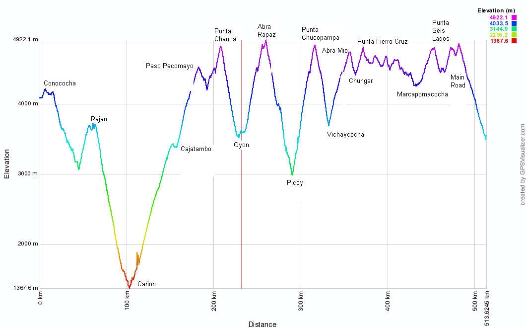
Stats – Conococha to Carretera Central
9 days
517km (16km paved)
12,200m climbed
11 x 4000m passes
16 Triangulo Chocolate bars, 1.2kg of pasta and 6 litres of cola each.

A nice easy start to our cycle. We bus to Conococha, having cycled that paving a few times before, then climb briefly to a small pass. Though we’re expecting the 3000m descent to Cañon to begin here this has to wait another day. This first day there’s an unexpected 1000m of climbing before Rajan.

We arrive in Rajan in the pissing rain, and fears surface that we’ve left our ride south too late in the season. En route to Rajan we are warned in 2 villages that the Rajanites are a bad, unfriendly lot. Which of course turns out to be untrue. Neil did have some uncomfortable moments fending off kisses from a drunk campesino in the main square though… The graffiti is of an educational kind. ‘He who studies, triumphs!’

In the bright morning sun we descend the 2300m to Cañon. Slicing through hillsides, the scenery is on a scale too vast to contemplate.

Descending into the depths of (Gran) Cañon we barely pedal for 40km. Gliding above we spot more condors than in the whole of our 5 months in the Cordillera Blanca.

A sinuous road, weaving in and out of dry side rivulets. The descent has to accommodate numerous photo stops and takes over 2 hours.

Number of vehicles seen in that time? Zero.
The night before it had rained cats, dogs and toffee apples.

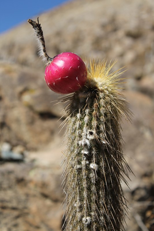
Who ate all the other cacti? Oh, that’ll be you on the left then.

As sure as night follows day, a long descent in the Peruvian mountains means you’ll be crawling uphill for the next day (or two). 2300m down from Rajan to Cañon is followed by 3200m up to Cajatambo and Abra Pacomayo.

And just as climb follows descent, hanging on the wall next to the depiction of the Last Supper is sure to be a titty calendar. Or, in the more respectable establishments, a scantily clad gringa advertising some ironmongers of transport firm. But maybe the backlash has begun. Here in Cajatambo someone had covered this chica’s modesty by making a paper mini-skirt for her!

The October rains have come. Fortunately the climb to Abra Pacomayo only has a few puddles, and no mud.

We arrive on Paso Pacomayo early enough for the skies to be clear. It’s never long in this part of the world at this time of year before the lovely photogenic clouds turn to lightning-spitting cumulonimbus though.

We begin the short descent from the pass and soon reach a junction. Rather than consult our GPS which has the track Neil has planned on Google Earth, we just assume the wide road with the good surface leads to Oyon, the district capital. Turns out it doesn’t, though it takes a while for the pin to drop. We climb back up for an hour and take the muddy track to Oyon. A 2 second glance at the GPS would have seen us take this in the first place.

The blue skies turn nasty. Just in time to hide from a violent hail storm we reach Karina’s huts and shop. She turns out to be well educated and super-friendly. We put up our tent by her hut, are invited in for food and drink, and hear about how terrible she found living on the coast when she had to go there during a difficult pregnancy. Soon after Genesis, her beautiful smiling baby, was born 8 months ago she moved back up here, to the back end of la nada.

Pay your bills now! The notice reads: to all villagers of Cashaucro, please pay your water and electric bills for 2011, 2012, 2013 by this Saturday or it’ll all be cut off! The debt collection systems in this part of the world put British Gas’ to shame.

You ain’t seen me, (scoffing all the borachitos) right? These tasty, rum-laced cakes have been a staple of our Peruvian diet for months now. The moment we reach Oyon at lunchtime on day 4 we raid the cake shops.

The following day and we’re climbing again on a typical Peruvian road. This will be an enduring memory of our 8?10? happy months in this wonderful country.

From Oyon we cross a 4900m pass, and outpace the rain down to Rapaz. We’d been sceptical as to the existence of the road, but it was very much there. The village turns out to be a friendly, interesting and quite large place. Unlike in Ancash, there are old buildings around – this colonial church survived the devastating 1970 earthquake. We bump into a miner whose mum lives in the street next to us in Vichay. Even in the immense Peruvian cordillera, the world is a small place.

From Rapaz we descend 1000m down a fascinating quebrada, towered over by these rocky ribs – hundreds of metres high. At night we camp at the Huancahuasi hot springs – nothing like a soaking in some iron and cobalt waters to reinvigorate the legs! Turns out they need reinvigorating. The following day’s climb is a beast.

Some non-threatening afternoon clouds, for a change. We admire them from the thermals.

From our thermal camp we descend to Huancahuasi, take the obligatory mural shot, then continue down to Picoy, at a lowly 3000m.

Then begins the 1900m climb to Abra Chucopampa. In Oyon everyone insisted there was no road over this pass to Vichaycocha. There is, and it’s brutal. Loads of sections over 10%, and in the mud at the top we were having to pause every 30 seconds to catch our breath. It’s been a while (well, our last time in Peru) since a pass has kicked our asses so badly. These sheep, and one moto, were the only traffic we saw all day.

Near Punta Chucopampa the pastel coloured rocks give plenty to amuse the eye on our frequent rests. It’s no wonder really that mining has been a mainstay of the Peruvian economy for centuries.

Showing the strain. After more than 8 hours of climbing we make it to the Punta Chucopampa.

The descent’s a good one, though equally steep. After a few kms we camp in a corral. The cloud obscures all views.

So we get a nice surprise on unzipping the tent door in the morning. Our camp in Maquin is surrounded by some lovely rock walls.

After another climb, this one easy, we reach the large dammed lake at Chungar. It starts raining, and we’re invited in again for some lunch with Johan’s family. They’re from the town of Huayllay (founded by Geordie settlers in the mid-18th century) but are embarking on a quieter life in Chungar. They’ve built a small house and are beginning to set up a trout farm on the lake. With about 4 neighbours and almost zero traffic on this road, we hope they’ll be happy in all the silence up here.
")
After a few hours the rains stop and we climb to the next pass, Punta Fierro Cruz.

But it’s late, so we camp at 4700m near the top. Expected lake views never materialize as it hails and snows much of the night.

The morning ride is somewhat chilly. And, dare we say, slightly miserable. As ever, we’re grateful for our mountaineering gloves.

Then comes the only flat section of road between Huaraz and Huancavelica. All 5km of it, following a water channel. It’s muddy, then becomes muddier as we join the main Tanta-Huayllay road for a while – plenty of mine traffic on this section.

Leaving the muddy main road, there’s a lovely stretch past more lakes and some snowy peaks to Yantac. At 4650m this is the highest village we’ve encountered in Peru. One side of the Plaza is this lovely church…

…while the middle of the square is dominated by this. It’s difficult not to fall in love with sculptures of such undeniable beauty.

We continue for an hour to Marcapomacocha on a day which saw plenty of sun, and on which we were overtaken by 10 hailstorms. We’re wet and chilly again, but knocking on the Mayor’s office door leads to the keys to this pseudo-grand hotel being produced. Over and over again in Peru we’ve seen big plans not being completed; the money always seems to run out with 95% of the job done. Fortunately this isn’t the case with roads in this country, which are inevitably excellent. Almost every 1-llama-village has a rideable road to it.

The next day, our Google Earth planning reveals a weakness. After crossing a 4800m pass we descend 400m, then take a small road we know leads over an even higher pass to the main, paved Carretera Central. But after 150m of climbing we reach a barrier across the road and this sign. ‘Halt! Under order to shoot’, it reads. We continued anyway, reasoning they wouldn’t bother getting the firearms out for a couple of cyclists. Plus, we’re climbing at such great speeds (3.5-4.5kph) that we thought it unlikely that any of the security men would be good enough shots to harm us…

But then we get to the mine buildings. These guys were willing to let us pass through, but the angry security boss arrives and tells us very firmly that this is a private road, and we must turn around now. Not sure why Neil’s looking so happy here as we lost more than half a day returning back over Punta Seis Lagos for the normal route to the Carretera Central. In the first minute on this horrible road we see more traffic than in the previous 9 days combined. Fortunately it’s a quick 30 minute downhill whizz until we turn off the paving again….
Click here to see our full Flickr Photoset for Part 1 of Peru’s Great Divide.
[flickr_set id="72157636812287854"]
First time visitor to you site. Loving the photography. What an adventure!
Thanks Phil! Peru is amazing for dirt road biking adventures…we don’t know of a better place…
Found your website from whileoutriding. Nice write-up, looks tough yet awesome at the same time! Do you guys have the gpx? Currently inching my way down to South America and looking for route ideas…
Hi Nick,
Yep, riding down Peru has been incredible, but tough at times! We’ve been taking gpx files of our whole route and will put it up on our andesbybike site before the rainy season ends. I wouldnt recommend it before April/May – too much mud and too many storms!
Riding vicariously with you. Love the reports and photos. Thank you for taking the time to share your adventure.
DmmyDiva
Cheers Kellie – the Andes reports and photos will continue for another few months – hope you continue enjoying them!
I have been following your adventure a while now. I get goose bumps and tears in my eyes when I see your pictures. i don’t what to say…simply superb!
Gracias amigo! We had goose bumps and tears in our eyes yesterday, crossing a pass in the hail…
Awesome post! Can’t wait to exchange stories at some point. I have the same mural pic, of course (-; And wait till you see our mud pics…
Thanks so much for sending details of the route. It’s kicking my butt too, but I’m loving it!
Definitely, a classic ride.
Awesome post! Can’t wait to exchange stories at some point. I have the same mural pic, of course (-; And wait till you see our mud pics…
Thanks so much for sending details of the route. It’s kicking my butt too, but I’m loving it!
Definitely, a classic ride.
Btw, you are the mining route masters!
Ah, Peruvian mines…we love ’em and hate ’em. Big scars, but great cycling roads…
Glad we got over that pass above Picoy before the real mud arrived!
You’ll be glad to know it’s been classic all the way to Cangallo, where we are now.
Stats to come!
… and where’s the stats for part 2? we’re waiting for them!
Hi Guys,
Loved your post on Peru’s Great Divide route. Any chance you can share more details of the route or maybe a gps file? I plan to get over there at some stage myself.
Thanks
Jarrod
Melbourne, Australia
Hi Jarrod,
We’ll be putting the info and GPX files up on Andes by Bike in the next few months.
cheers
Neil
Hi PikesonBikes!
Great info here! We are a brazilian couple on a world tour and tomorrow we’ll head to Huaraz.
Amazing pics and stories! We’ve been gathering some info and I can’t remember where I’ve read about the GPX of the route. Where can we find it?!
We’ll acclimatise a few days in Huaraz and hopefully the weather will be better… so far raining a lot but we gotta move!
Thanks a lot,
André and Karla.
Hi guys,
Enjoy Huaraz! The info about the PGD starts here: https://andesbybike.com/peru/routes/cordillera-blanca-to-carretera-central/
cheers
Neil
BTW, when you say you were carrying 15Kgs each, were you considering the bike?!
If not (which I think is the case) how heavy was just the bike?!
Cheers!
No, that wasn’t including the bike! They weigh about 14kg each…