Because it’s there: Cycling Uturuncu

There’s nothing we find quite so irresistible as a high Andean road. Add in the possibility of continuing on foot to a 6000m summit and it’ll soon weasel its way onto our ‘To Do’ list.

Which is why we’ve had our eye on Uturuncu for a while. The road up to the old sulphur mine near the northern top is one of the highest roads ever built. We’d read on the web that landslides now block the track, so it is no longer motorable to the mine (or col between the mountain’s two peaks at 5760m), so as we left sleepy little Quetena one morning we envisaged cycling to the slide, then walking to the top from there.

But the road, covered in fresh jeep tracks, just kept on going, and to our delight was almost all rideable. By early afternoon we’d reached 5550m, and decided to camp. In the morning a passing jeep driver explained that some tour agencies had opened the road all the way to the col, so that clients could be driven up, then amble the 250m up to Uturuncu’s south summit. At 6008m this is the highest peak in southern Bolivia, the lowest on the Andes’ official list of 102 6000ers, and surely the easiest mountain of its height in the world.

At the col we were pedalling past eggy fumaroles on a track under which was a turbulent gurgling of sulphur. We left the bikes and walked up the good path to the summit – in good weather no mountaineering kit is needed here: a pair of trainers and some warm clothes will suffice. From the top, a myriad of lakes are visible in all directions, and having savoured this we descended to the bikes and tried continuing onwards to the old mine. But this section of road has no tourist worth. After 20m more of ascent it deteriorated, and scouting higher on foot showed there was little point continuing further – littered with rocks, the surface was, to us at least, unrideable in either direction. We turned round and rolled back to town.


Uturuncu, seen from Quetena

Uturuncu, seen from Quetena. By road it’s 30km from the village to the col between the two peaks.

Climbing to Quetena

The surface on the track to the mountain is an interesting one. Sometimes bedrock…

A sandy section near Quetena

…occasionally sand. Most of the kilometer or so we had to push en route to the col was on these lower, sandy sections near the village, before the real climb began.

Nearing 5000m on the climb up Uturuncu

13km from Quetena, and at 4350m, the climb really begins. But with it the surface improves…

The road on Uturuncu

…and we grind our way up to the sky.

The road on Uturuncu

The Marathon Extremes work well, though we do find ourselves wishing we had fat bikes quite often when we’re in this area.

Still pedalling up Uturuncu

At around 5000m the gradients begin to crank up…

Pushing up Uturuncu

…and there are infrequent sections we have to push. Fortunately, despite loaded bikes (with camping kit and 2 days of food and water), these are always short.

Climbing to the col

Soon we’re pedalling again. From this distance we never spotted the highest parts of the road, near the col, though it’s not long until we find out it really is there.

Taking a rest on the climb to Uturuncu

As the altitude increases, so does the frequency of our stops. The road climbs from 5200m to 5500m in 3km, and we’re having to catch our breath every 100m or so…

The steep climb on Uturuncu

But the road is good enough to pedal up…

Tiny cyclist, 6000m peak

…so that by mid afternoon we’re being dwarfed by the peak. Haz is the speck on the right.

Climbing to Uturuncu

Then we meet a jeep, descending from above. It left Quetena at the same time as us, drove to 5550m, from where the 4 tourists inside climbed to the top. ‘But the road is cycleable as far as the col’ they tell us. Great news!


The road to Uturuncu

Jeep tracks. Soon to be joined by a couple of bike ones.

Near the col on Uturuncu

We camp at 5550m, then in the morning it’s a short 3km hop to the col. The tourists were right – we can pedal almost all the way there. On the final kilometer the gradient finally eases.

On the summit of Uturuncu

From the col it’s only a 40 minute walk to the summit. The mountain boots we brought with us from the UK back in May get a first run out. As it’s such a gentle one, there’s no time for blisters…

Hanging out on Uturuncu

As with most Puna peaks, someone has built a wall at the top to shelter from the usual breeze…

Investigating the mine road above the col on Uturuncu

In 20 mintutes we’re back at the bikes, and decide to investigate the continuation of the road which heads up to the old mine on the northern peak. But with no tourists interested in going up this way it’s unrideable, so we turn back. Our GPS says 5777m – the highest our bikes have yet been, or are ever likely to go…

Descending from the col on Uturuncu

Then it’s the whizz back to town. Under this section of road, the mountain is gurgling and bubbling away…

Descending Uturuncu

Not much pedalling needed for the first 15km or so…

Descending Uturuncu

Down down down…

Descending the track on Uturuncu

The long traverse back to our camp and panniers.

Nearing Quetena, on the descent from Uturuncu

Gear back on the bikes, we continue to town, to find the only decent shop closed, with its owner gone to Uyuni. We scrabble around and find some Pepsi and a few packets of Chizitos (Bolivian Wotsits) to celebrate with before continuing on to San Pedro


[flickr_set id=”72157638013399875″]


Back in Bumpy old Bolivia

This wasn’t our first visit to Bolivia’s inhospitable Sud Lipez region. As true Gringo Trailers eleven years ago we zoomed through on a four day jeep tour. Then, in 2010, we pedalled through with a sense of awe. The ‘Lagunas’ route is a challenge most cyclists feel they must complete on a journey along the Andes. Beforehand we pored over maps, gleaned information from other cyclists’ blogs and psyched ourselves for the toughest ride of our lives. Then, we were surprised to find that though the roads were corrugated and sandy and the wind exhausting, the fabled ‘Lagunas’ route wasn’t as tough as it was built up to be. Jeeps seemed to pass continually. This was no wilderness route, and navigation wasn’t tricky. As Amaya mused when cycling here,  ‘Getting lost in southwestern Bolivia … is about as likely as getting lost on your way to the supermarket.’

Despite the jeeps, we loved the wide open spaces and went on to explore the Bolivian highlands for a further two months, then decided this year to come back for more. But a return to Bolivian roads came as somewhat of a shock after the well maintained surfaces in Peru. Our selective amnesia had remembered the big skies, cone-shaped volcanoes and colourful lakes but eliminated the bumpy discomfort. Or maybe the surface on the route through San Pablo and Quetena was just worse…

On a Bolivian road you rarely have time to look around. Eyes need to remain fixed on the few metres ahead to negotiate the next obstacle. Sometime it’s corrugations; sometimes sand. Ocassionally it’s rocks. Or a river, thrown in just for fun. We found ourselves wondering what a different experience cycling here would be if the roads were improved; or even paved. Looking around to enjoy the scenery would be possible. All routes would take half the time. You’d hardly have to carry any food and water. But perhaps we all traipse to this corner of the world for the misery factor?

We also pondered what cycling Sud Lipez would’ve been like before it was on the the gringo to-do list. Was this yet another destination that it’s now ‘too late’ for? Now in the tourist honeypot of San Pedro we can’t help but wonder what a potty business tourism is. If we travel to discover new cultures and experiences why do touristy places continually evolve to become more like back home? Why do we demand coffee and pizza when we’re in the middle of the driest desert on Earth?

Hmmmm coffee……

IMG_2463_2133x1600_1066x800

From Cusco we caught a bus to La Paz to see Raul and Linda, and to meet Alvaro, for whom we’ve been ‘padrinos’ for the past few years.

IMG_2473_2133x1600_1066x800

La Paz is still pretty much our favourite city in the world and is made even more special by now having some good friends in town. Here we are at Alvaro’s home, where his charming mum Jeanette cooked us up a feast. After 5 happy days in town, we dragged ourselves away and catch a 4th bus in a week. This one goes to dull old Uyuni, where luckily more amigos await.

IMG_1809_1067x1600_571x800

In the form of these Three Little Piggies who’ve just been to market. And come back with 80 peanut bars and 60 Sublimes… This is Anna, James and Sarah whom we met months ago back in Huaraz. Our taking the bus from Abancay to Uyuni meant we could catch up again before heading out to the Sud Lipez.

The first day out of Uyuni on the road to San Vicente

The first day out of Uyuni on the road to San Vicente couldn’t have contrasted more with our time in Peru. The road was totally flat; there wasn’t a bend in sight. Made for a gentle reintroduction to heavy bikes. With 10kg of mountaineering kit for the Puna to lug around, we’re using front panniers for the first time in nearly 3 years.

IMG_2518_1067x800

In 2010 it took us 10 days to find a Bolivian road sign. On the route from Uyuni to San Pablo and Quetena there were plenty, including this beauty.

IMG_1860_2400x1600_1200x800

Day 2 saw us reach some climbs. Steep ones too – the Bolivians don’t go in for corners. We saw about as many zigzags in 10 days as you’d normally see in 10 mins in Peru.

IMG_1871_1200x800_1200x800

At lunch time on the second day we reach San Vicente. This is the old part of the village, a larger new part has sprung up to house workers and families from a big mine. I’m sure most of you recognize this sad little village from Hollywood. It’s the unlikely place where Butch and Sundance were finally cornered and killed. Tearing out of that casita, all guns blazing and all that…

IMG_1892_2400x1600_1200x800

The route to San Pedro de Atacama turns out to be all rideable, apart from a few pushes through rivers and a couple of tiny sand dunes. Occasionally though there are huge gashes in the road, and we have to follow the short detours taken by the jeeps.

IMG_1894_2400x1600_1200x800

Here’s one of those sandy parts. This is about 10m of the 50m we had to push this week.

IMG_1913_1067x1600_534x800

But the surface is rarely good. Much of it looks like this.

IMG_2588_2133x1600_1066x800

The route is reasonably quiet as far as Polques, though it’s by no means a wildernerness experience. Each day we are passed by 15-20 vehicles.

IMG_1948_533x800

Finding serene campsites is never a problem. As we carried water all the time and the terrain is mostly flat, we just camp when we get tired. This is in a dry lake bed.

IMG_1951_1067x1600_534x800

Sections like this were not uncommon.

IMG_2004_1200x800

But villages like this were unique. San Antonio Viejo used to house the workers from a now defunct mine. This is the church.

IMG_2009_2400x1600_1200x800

And here are some workers’ quarters.

IMG_2039_1067x1600_534x800

Having left the rains and storms of Peru behind, cycling became a different experience. We no longer had to rush to put in the kms before the threatening afternoon clouds materialized. Added to the fact we are now 10 degrees further south and the days are longer, meant far more hours in the saddle.

IMG_2638_1067x800

Rolling hills and ever changing shadows…

IMG_2055_2400x1600_1200x800

Before Quetena is a 4900m pass, the highest of the route. It turns out to be a tough one, with steep gradients and the obligatory crap surface. Staying in a straight line isn’t easy on the climb…

IMG_2068_1200x800

It is on the descent though. Here’s Haz rolling down to the sandy shores of Laguna Morijon. Uturuncu puts in a first appearance.

IMG_2087_1200x800

It’s pretty, and we cruise down to the lake, where the surface turns into…

IMG_2093_2400x1600_1200x800

…a gravelly mess. Throw your weight one way…

IMG_2094_2400x1600_1200x800

…then the other.

IMG_2099_1200x800

But as always, things improve once we leave the flat sections and begin climbing again.

IMG_2146_2400x1600_1200x800

Though it is occasionally wet. There are plenty of rivers and streams around on the way to Quetena.

IMG_2151_2400x1600_1200x800

Which turns out to be a depressing little town with not much going on. Not for the first time in Bolivia the thought ‘Can you imagine living here?’ lodges in our minds. This place has a sad number of half wits and mentally retarded residents and even watching perfectly ‘with-it’ shopkeepers battling to calculate how much change we’re due is enough to make you want to weep. Rarely on our travels have we encountered a country where the mental arithmetic is so poor – back in 2002 we remember being struck by it.

IMG_2313_2400x1600_1200x800

After a 2 day detour to climb Uturuncu, we continue on to Polques, and the main tourist route through the Lagunas. On the way is this incredible climb. Something like 400m in 3km, and on a sandy surface too…

IMG_2331_2400x1600_1200x800

On the other side are some beautiful lagunas, including the one peeking out on the left – Kollpa Laguna.

IMG_2333_533x800

Given it’s a beachless, landlocked nation, Bolivia must’ve shouted loudly when God was apportioning the world’s sand…

IMG_2908_600x800

Though navigation is pretty straight forward, working out which is the least sandy track isn’t. Let’s try over there…

IMG_2336_2400x1600_1200x800

This visit to Sud Lipez was nowhere near as windy as our last one. The first 5 days there was barely a breeze. As we honed in on San Pedro the afternoon gusts caught up with us though. Makes everything twice as hard…

IMG_2904_2133x1600_1066x800

And not just the cycling. Even getting dressed becomes a challenge.

IMG_2340_1067x1600_534x800

Particularly when it turns cold. After a week of nights when the temperature barely fell below freezing, we camp on the Salar de Chalviri. On waking we worry our thermometer has broken and the mercury fallen out the end. Then we realize it’s just a few cms lower than usual, at -17C.

IMG_2934_1067x800

At Polques we encounter more flamingoes, and Mannfred Mann’s classic lodges in our heads. But close-up encounters with these ugly birds kind of ruin the song. ‘On our block all of the guys call her flamingo, ’cause her (prehistoric dinosaur head-) hair glows like the sun, and her (beady little) eyes can light the sky…’

IMG_2372_2400x1600_1200x800

There are nice pastel colours around, but being on the main tourist route is no fun at all. The worst kind of road: an unpaved highway. Every minute for the first 3 hours, we’re covered in a thick coating of dust.

IMG_2388_2400x1600_1200x800

But the surface occasionally improves. The road is thankfully the bit on the right, not in the middle.

IMG_2405_1200x800

We expect to make it from Salar de Chalviri to San Pedro in a day, but the afternoon headwind is just too strong. At Bolivian immigration we’re kindly shown to the abandoned hut where many a cyclist has spent the night. Not sure what these machines are for – they evidently don’t get out and about to clear the routes very often.

IMG_2410_2400x1600_1200x800

The morning is still as usual. After a short climb up to the Chilean paving, Haz is expecting to break all kinds of land speed records on the descent to San Pedro. Sadly the wind starts up before we begin our descent, and despite frenetic highest-gear pedalling, neither of us can even approach 70kph…

[flickr_set id="72157638014189473"]


Riding Peru’s Great Divide: Final Statistics

This is one of the best routes we’ve ever taken, with spectacular, varied scenery and friendly locals. We can’t overemphasize how important it is to go light, however. There is a massive amount of climbing to do (much of it at high altitude – over half the time you’re above 4000m), the gradients on some sections are super-steep, and there are parts with challenging surfaces. A bike-packing setup would be perfect.

We took less than 15kg each, carried in rear panniers and front bags. This worked well – we had all the gear we needed. (This included down jackets, mountaineering gloves, waterproof jackets and trousers, thermals, mountaineering tent, 4 season bags.). There are regular water sources en route, so 90% of the time we didn’t carry any, and the longest we cycled without seeing a shop was about 2.5 days.

We will be putting up detailed information on our Andes by Bike site before next season. The best time for this route is dry season in Peru: May to September. Outside of this you’ll encounter lots of afternoon rain, lightning storms, and mud.

Stats: Conococha (near Huaraz) – Santa Rosa (near Abancay)

Days of cycling: 26 (+2 rest days)

Distance travelled: 1579km (181km paved)

Amount climbed: 36,350m (about 2500m on paving)

4000m passes: 30 (depending how you define a pass)

Average speed: 10.4kph

A typical Peruvian road

Maximum Altitude reached: 4990m (Punta Pumacocha and Punta Caudalosa Chica)

Longest day by distance: 96km (Licapa – Vilcanchos)

Longest day by time: 8h40 (Vilcanchos – Chuschi)

Most Climbing in a day: 2500m (Socos – after Abra Putongo)

Steepest Incline: 24% (On the climb to Abra Llamaorgo from Viñas)

Highest Daily Average Speed: 22.7kph (Above Sañayca to Santa Rosa – 1500m down, 30m up). Second Highest Daily Average Speed: 13.4kph (Licapa to Vilcanchos).

Number of times we climbed 400m in 4km: 3 (above Parquin, at the top of Punta Pumacocha and above Chilcayocc)

Passes that kicked our asses: Punta Chucopampa (4860m), Abra Suijo (4710m), Punta Pumacocha (4990m).

Amount we had to push: 0km (H), 0.2km (N – on the climb to Abra Suijo)

Days we got rained on: 15

Days we cycled with thunderstorms around: 10

Maximum Temperature: 44C (well, we don’t know what the real maximum temperature was – this was the highest reading given by our cycle computer in the strong Andean sun)

Minimum Temperature: -5C (camping near Abra Putongo)

Punctures: 2 (H)

Cycle Tourists met: 0

Fuel: 46 chocolate bars, 3450g pasta, 29 menu meals and 18l of pop guzzled each.


Elevation Profile

Conococha – Huancavelica

Conococha-Huancavelica


Huancavelica – Santa Rosa 
Huancavelica- Sta Rosa

Daily Climb

Daily Climb


Riding Peru’s Great Divide: Part 4 – You say Subidita, I say Subidazo

Cycling in Peru soon teaches you one thing: that the scale of this country’s landscapes is immense. So vast. So huge. A country so vertical that local people can’t even see a 1000m ascent. A climb bigger than England’s highest mountain is so insignificant as to not register.

We often ponder as we’re cycling down and up Peruvian hills, what we’ll feel when we’re back pedalling in Europe. Will we be hard to impress? Or does scale not really matter?

These days we’re already thinking and acting a bit Peruano. Six months in a country does that to you. We’ve started discounting paved passes as not being ‘real’ climbs. They require far less effort, and so are, comparatively speaking, ‘flat’. We hunch over our menu soups, left elbows on table, face low to bowl. And why not? We spill less that way. We scrutinize bank notes to check for fakes. We enjoy extending our de freeeeentes (‘straight on’), and elicit giggles from locals by adding -pe to the end of sentences.

A foreign country has never felt so much like home.

As we neared the end of our route from Huaraz to Abancay the sheer variety of landscapes in this memorable month continued to surprise. From the gaping, arid, cactus-filled gorge at Cañon; to the high altitude Puna; the hundreds of lakes; the multi-coloured hills; the weird rock formations; the unparalled Rio Cañete; the bottomless Rio Pampas valley; right up to our final day of escarpments and plateaus near Chicha.

But throughout all this scenic flux, two things remained a constant. The warmth and friendliness of the campesinos. And the switchbacks.

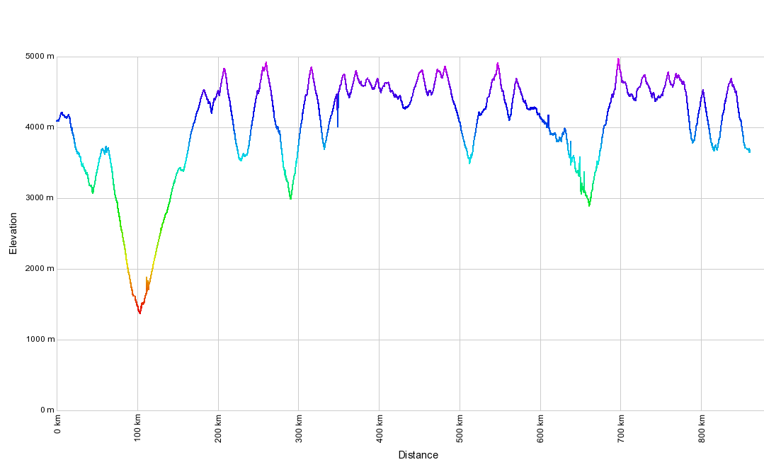
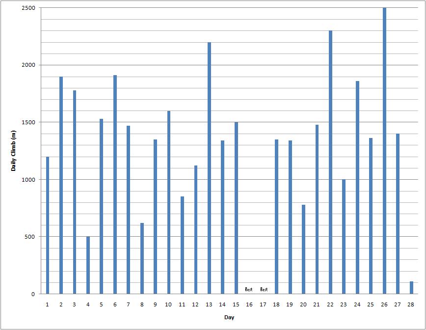
Four weeks and 1580km after setting out from Huaraz we jumped on a bus near Abancay. In that time we’d climbed over 36,000m, and descended over 38,000m. An Everest A Week. Some locals may think their country only has subiditas*. We thought them subidazos*. It was time for a rest.

(* The diminutive and augmentative of subida (climb).)
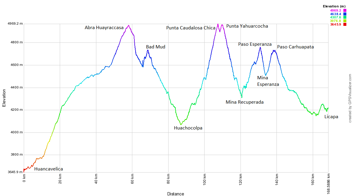
Elevation Profile Licapa-Sta Rosa Profile

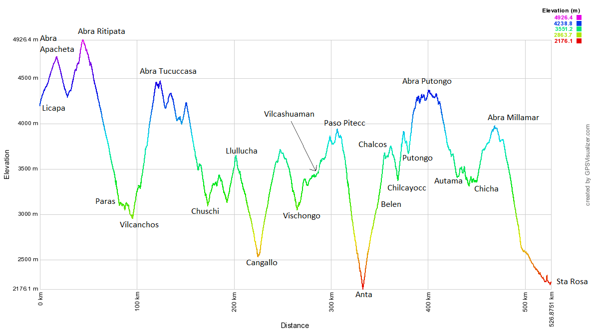
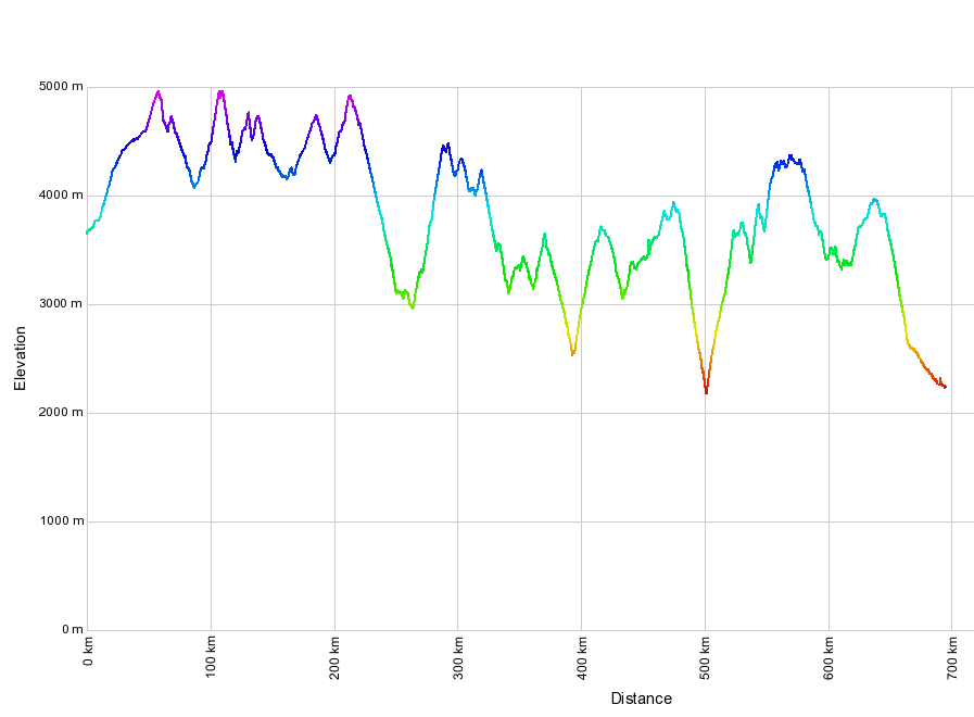
Stats – Licapa to Santa Rosa

8 days
539km (83km paved)
12,000m climbed
6 x 4000m passes

12 Chocolate bars, 600g of pasta, 6l of pop each (being in villages means less pasta and more pop and cakes – hooray!).

One of the few hairpins on the climb to Abra Ritipata

After turning off the paved Libertadores highway to Ayacucho, there’s a 2 hour climb to Abra Ritipata, which, for a change, features few hairpins. So we see less of the yellow and black unofficial National Emblem of Peru. There are still a couple of zigzags though, of course.

My GPS said 4950m

A sign! A sign! Imagine our excitement at finding this beauty. It means we don’t have to make up a name for the pass, or find a local person to make up a name for us. Our GPS reads 4950m.

Descent to Paras
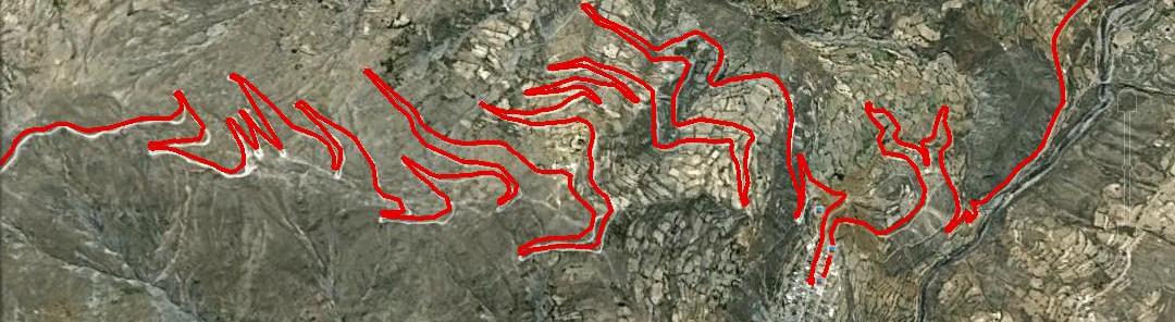
We’d been looking forward to the descent from the pass to Paras for ages. On Google Earth it looks like this.
The descent from Abra Ritipata

But to our great disappointment, on the day, the weather looks like this. Still, there are some colourful hills around.

On the descent to Paras

But it’s a damp afternoon, with mist and cloud in all directions. The 30+ hairpin descent is miserably wet.

Near Vilcanchos

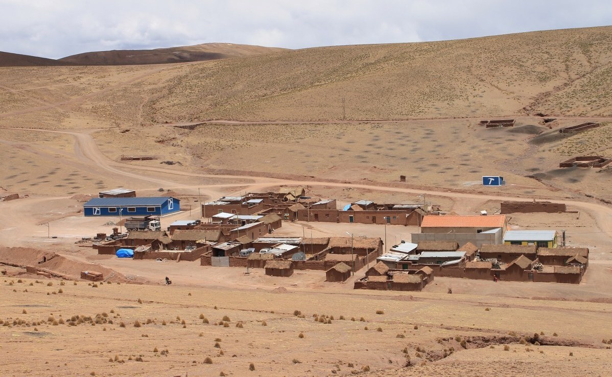
Once down in the valley depths, the sun comes out and we meet this work gang near Vilcanchos. In the villages, all the residents are required to give up time for community works.

In Vilcanchos

Here’s a more solitary, pensive member of the team.

Climbing above the Rio Pampas

The following day we head from Vilcanchos to Chuschi. It’s only 20km in a straight line, but there’s no road the whole way along the valley. One is being built however, and we’re tempted to bike-hike when some of the locals say there’s only a small section missing. Then there are mutterings about it being a 2 hour walk, and a subidazo at that, so instead we opt for the long way round by road. It turns into a mammoth 80km day.

A nice gent in Veracruz

An hour into the climb we chat for a while to this nice gent in Veracruz. Seeing as we’re now half Peruvian, we shake his, and half the village’s hand. A soft shake of course; no bone crushing occurs here.

These clouds had just given us an almighty drenching

Then, four hours into the climb on what amounts to a very steep farm track, the rain arrives. These are the offending clouds. The subsequent 2 hours are the most triste (sad) of our whole ride. We make it to the 4500m pass at noon. It’s 2C, and we’re wet to the core.

A shy chica, wearing a Chuschi hat

5km into the descent is the small village of Tuco. We’re looking a bit pathetic, and feeling it too. We hang around, hoping someone might invite us in for a cup of warming tea. To our delight, this girl’s dad obliges, and for this we’ll always be grateful. We continue, with a warm cinammon glow inside. The colourful hat is typical of Chuschi – all the women, and some of the men, wear it round town.

Late light on the way to Chuschi

In the late afternoon the sun comes out, so we can enjoy the long descent to Chuschi.

The Rio Pampas valley between Vilcanchos and Chuschi

But by now it’s getting late. This is the impressive Rio Pampas valley at dusk. We arrive in Chuschi well after dark, 13 hours after leaving Vilcanchos. Knackered after 9 hours of pedalling and 2300m of climbing, we head straight to bed in the Municipal Hostel.

We're indebted to Google Earth for this fantastic little shortcut to Cangallo

The next day we decide to take it easy, and have a short day to Cangallo. We’re surprised to come across a paved road, but then Neil’s GPS leads us onto a small, barely used 4×4 track. It turns into a great shortcut to town.

Heading for the rain near Cangallo

We pace it down to the provincial capital…the thunder has started early, and we don’t fancy another drenching.

Another Cangallo mural

Where would we be without Google Earth? This track didn’t appear even on the Ministry of Transport maps, and it looked so small when we first joined it, that without having viewed satellite photos we’d never have thought about venturing onto it.

Bike cleaning in Cangallo

Cangallo turns out to be a town full of murals…

A great shortcut to Cangallo

…and curious kids full of stories about everything that’s wrong with their bikes.

A ghostly bici

It’s Señor de los Milagros day, so we join the hordes processing around the Plaza. A ghostly bici crosses the flower-petal covered streets.

Cangallo, by the Rio Pampas

The next day sees us climbing again, away from the Rio Pampas and over to Vilcashuaman.

School advert, Putica

We pass some school adverts in Putica – a common site in Peru.

A father of nine, Putica

And in the same village meet Carlos, a proud father of nine. ‘What do you mean most people only have 2 or 3 kids in England? Do you need me to fly over there and boost productivty?!’ The local shopkeeper overhears and seems unimpressed. ‘You’ve got enough already! You can’t even keep your current brood properly fed!’ We sidle away…

The hills near Vilcashuaman

And pass through colourful hills on the way to the important Inca centre at Vilcashuaman.

The church in Vilcashuaman

In their usual tactful way, the Spanish knock down the Sun Temple, and replace it with a church. But it’s nice enough to look at, and seems well used by the current populace.

Inca wall, Spanish wall

The wall-building competition isn’t even remotely competitive. Incas 1, Spanish 0.

Plaza de Armas, Vilcashuaman

The Plaza is large, though not nearly as big as in Inca times. Despite featuring briefly in the Lonely Planet, our reception tells us this place receives few tourists. It’s of the ‘shake hands with everyone’ kind, rather than the ‘get pounced on by touts’ Cusco sort.


Street scene, Vilcashuaman

On a wander round town we observe some typical Peruvian street scenes. Animals share the streets with old bangers and 4x4s.

The 1700m descent to the Rio Pampas

As we’re leaving our hostel the next morning, the owner asks us where we’re headed. ‘To Saurama, then Andahuaylas’, we reply. ‘But how will you cross the Rio Pampas? There’s no bridge.’ Which explains why we couldn’t see one on the satellite pictures. We spend the next 2 hours going round town, asking about alternative routes to Abancay. The municipality workers are helpful, as are the taxi drivers. We end up with 2 options: head back north for a day to meet the main paved road, then follow this 3 days to Abancay. Or head south on small roads, which apparently lead to the town of Querobamba, and from there make it to the Nazca-Abancay paving.

Descending to Anta and the Rio Pampas

We opt for the latter, despite warnings that we’ll ‘sudar mucho’ (sweat buckets) on the climb up from the Rio Pampas at Anta. For the hundredth time a Peruvian exhales slowly and draws us ‘air switchbacks’. If he’s right, the climb up from the river is interminable.

Purple rock near Anta

The 1700m descent down to the river seems interminable too. It’s on an awful surface, which would’ve seen us regularly pushing, had we been unfortunate enough to be going in the opposite direction. But at least sections of the road and surrounding rocks are purple – such a deep shade of it, such as we’ve not seen before.

Nearing the Rio Pampas

After a few hours descending we near the bridge. The sign says it’s closed, and there are others saying it’s pedestrian only, but this doesn’t stop the occasional 4×4 sneaking over. The ‘air switchbacks’ manifest into reality. There are over 30 of them.

Crossing the Rio Pampas

The crossing’s a bit wobbly on a bike. We hate to think what it’s like in a vehicle, but as this is the only way over this huge river for tens and tens of kilometres, some drivers feel they have little choice but to use it.

The Rio Pampas valley

After overnighting in the 5-family village of Socos, where we’re put up in the village hall, we continue climbing. To our delight, for the umpteenth time this journey a descent on a bad surface leads into a climb on a good one. From the river at 2200m we can pedal the whole route, and don’t stop climbing until we’re at 3700m.

The Rio Pampas valley

The suspension bridge begins to look smaller and smaller as we wend our way up the zigzags…

With the girls in Chilcayocc

…and after a few hours we make it to Chilcayocc to hang out with a load of chicas. People have told us the climb above town is a tough one, and they’re right. For the third time since leaving Huaraz our route climbs over 400m in 4km.

Climbing above Chica

We make it to Putongo, then climb again. As we no longer have GPS information we’re having to stop at every junction and town, to ask in-the-know locals about which roads to take. This leads to an excellent shortcut, over a 4400m pass, to Soras, thus avoiding the descent to Querobamba. The next day we make it to Chicha, then climb once more to Sañayca. The scenery changes again – this day it’s all escarpments and plateaus.

A last Peruvian Camp

Night overtakes us before reaching Sañayca, so we set up one last Peruvian camp. As has become our custom we don’t bother straying far from the road – we’re pretty sure, having only seen one vehicle all afternoon, that there’ll be no traffic passing in the night.

A last Peruvian sunset

Our last Peruvian sunset is one to savour and remember. The next day it’s a 1000m descent to the paving, and we pedal downhill on this for 30km to Santa Rosa. In 2010 our route took us from Tierra del Fuego to Santa Rosa, so having linked up the journeys we jump on a minibus to Abancay, then a bus to Cusco. These 6 hours remind us why we no longer backpack. The minibus is nearly hit by a landslide (ok, so this would’ve been far worse on a bike), then the kid in front of us pukes, and as the window is open flecks of vomit fly in our faces and hair (this has yet to happen to us while biking). Then, on the bus to Cusco we come perilously close to being pushed into a river by a juggernaut coming at speed round a blind bend…

Acknowledgements: We’d like to thank the Peruvian Ministry of Transport and Communications for making this trip possible, through the building of such an excellent network of unpaved, unused mountain roads. If the Indian Prime Minister should ever read this, we suggest, Sir (Your Highness?), that you fly some Peruvian engineers over to the Himalaya to teach the Border Roads Organization et al how it’s done.

[flickr_set id="72157637393149655"]

Riding Peru’s Great Divide: Part 3 – Good Mud, Bad Mud

For a few days after leaving Old Huanky the combination of rainy season and dirt roads began to manifest in some slightly muddy surfaces. As we manoevered our front wheels through puddles and round the brown stuff, Haz contemplated retiring from cycling, to pursue her chemistry studies. A PhD in ‘The Rheology of Mud’ briefly beckoned.

Mud

Collins’ definition :

noun a fine-grained soft wet deposit that occurs on the ground after rain, at the bottom of ponds, lakes, etc.


Extract from Wikipedia:

Clay soil can pose problems for traffic when moisture is present. A road built upon such soil may become stable over time as the packing of the soil will make it more water-resistant. However, any attempt to grade it can be disastrous, since excess water can then enter the surface and will be worked in by traffic, transforming portions of the road into a mud bog that can trap vehicles.

When we weren’t gawping at the still-spellbinding scenery, the road surfaces were keeping us entertained, or at least demanding our full attention. Climbing to Punta Caudalosa Chica we happened across the bad mud.

Bad Mud

The coagulation of dirt and gravel around the forks of one’s bicycle. In extreme cases it can prevent one from reaching Andean passes.

Easy climbing gave way to a sticky, cloggy surface which was impossible to ride. As we were only 5km and 250m from what we suspected was the highest pass of our route, we dismounted and began pushing. But within 20m our wheels were too jammed to move and our shoes had become resoled with 2kg dinner plates. Often in the past we’ve made things difficult for ourselves through pig-headedness and stubbornly refusing to turn round, but this time we knew we were beaten. We descended to some workmen (‘we told you not to go that way‘), and threw the bikes in a stream for an hour long bathing session. Then began a long detour to attack from the other side.

The following day, after hours of overnight sleet and snow, we pedalled a far muddier looking mine road. But this was good mud, and it wasn’t too much effort to slice right through it.

Good Mud

A fine watery deposit that slows one’s bicycle and covers one from head to foot, but does not prevent forward motion.

More the fool who deviated from the tyre tracks to the side verges however – the accumulation around forks would then immediately begin again.

A couple of passes and some puddle bike-washes later we descended to the Pisco-Ayacucho paving. En route the locals continued to shower us with hospitality, and the scenery to be fantastic.

Our route south from Huaraz is turning out to be an absolute classic.

(And we’re not the only ones to think so. Check out Cass and Kurt‘s recent blog posts – they’re following closely behind and both know more than most about cycling the world’s dirt roads.)


Elevation Profile

Huancavelica-Licapa


Stats – Huancavelica to Licapa

3 days
169km (54km paved)
3,470m climbed
6 x 4,000m passes (well, kind of)

6 choc bars, 700g pasta, 1.5l pop each.


IMG_1089_1200x800
Leaving Huancavelica we have our first easy day since Huaraz. You really appreciate the speed at which you can climb on paving after a few weeks on the dirt. This being Peru, there was still plenty of ascent though – more than 1300m from town, over Abra Chonta and onwards to Abra Huayraccasa.
An odd hairpin bend near Huancavelica

En route to Abra Chonta is this odd hairpin bend. We think it’s a left-over from an old railway line on which the road is built. Haz couldn’t resist returning to cycle round it. Choo choo!

Nearing Abra Huayraccasa

At paved 4880m Abra Chonta is the turn-off for Abra Huayraccasa, only 3.5km of easy dirt climbing away. The clouds are enthralling, but soon bring snow.

Abra Huayraccasa - my GPS said 4,976m

The Highest Pass in the Americas! Or so most maps still claim. The sign has been repainted without the claim, but still states the altitude as 5059m. Our (and everyone else we know’s) GPS gave it as around 4975m. It briefly enters our ‘10 Highest Peruvian Passes‘ list, only to be displaced the following day…

Climbing to Punta Caudalosa Chica

An hour into our descent from Huayraccasa the snow arrives. We find a very unlikely picnic area, where we’re able to cook and eat in a small hut, then put up our tent a few hours later once the snow ceases. In the morning all is white as we begin the short 400m climb to Punta Caudalosa Chica. It all begins easily enough…

And then the road turned muddy...

…until the surface turns to BAD mud.

It wasn't long before we admitted defeat

‘Bugger’ was heard to be muttered a few times.

The wheels weren't spinning too smoothly at this point

The wheels weren’t spinning too smoothly at this point, so we admitted defeat and turned back.

Bugger

Probably didn’t do the drive chain any good on the 1km descent to a stream…

Bathing time

…in which the bikes were given a well needed hour of scrubbing.

Back on the main road

Back at the main road we run into some workmen we’d chatted to the day before. ‘We told you not to go that way’ they say. And it’s true, they had. We’d assumed however that they meant the route we wanted to take was a private mine road (which it turns out it wasn’t), not that the surface was a sticky brown mess.

At the shop in Mina Caudalosa Chica

We resign ourselves to the 1700m descent to Lircay, where we know we can pick up a dirt road over to Licapa and the paved Pisco-Ayacucho highway. On the way we pass through the Caudalosa Chica mine. It’s more of a village/mine, with shops, restaurants and many families living there.

The new swimming pool at Mina Caudalosa Chica

We’ve been surprised by how little we’ve seen in the way of mines this route – Caudalosa Chica was only the third we’ve passed close to. We quite enjoy a mine-cycle every now and then; the enormous machinery is oddly compelling. Plus they build random other massive things like this new swimming pool.

Nearing Punta Caudalosa Chica

On the way to Lircay we have a stroke of luck. At the junction for Recuperada, there’s a taxi coming down from what we assumed from Google Earth was a private mine road. But the driver tells us otherwise – we’re allowed to use this road, and can get up to Punta Caudalosa Chica the back way, after a long detour. Great news! Here’s Haz at about 4900m, climbing through mud to the pass.

On Punta Caudalosa Chica (4990m)

But the mud is nowhere near as bad on this side, so 6 hours later than expected we make it to the top. The GPS reads 4990m, which probably makes this the highest point of our route. Here’s Pike extracting some mud from his front brakes for the 50th time that day.

On Punta Yahuarcocha (4980m)

After a slight descent from Punta Caudalosa Chica, we can’t resist a very short detour up to Punta Yahuarcocha. On the climb, the snow eases and the sun comes out.

On Punta Yahuarcocha (4980m)

It’s a beautiful spot, particularly with the wind blowing the cloud and spray about. Our GPS says 4980m, which if accurate would mean that Abra Huayraccasa, far from being the Highest Pass in the Americas, is in fact only the third highest pass within a 10km radius.

Descending from Punta Yahuarcocha

Descending from Punta Yahuarcocha is this colourful hill. Cerro de los Siete Colores eat your heart out…

Haz gatecrashes another photo

Then at 16:00 the snow we knew was coming all day, arrives. Luckily we’re near Margarita’s (L) house, and she allows us to sleep under the cover of some of her outbuildings. She’s the first person we’ve met in Peru who speaks no Spanish, so we revive our Asian-learned sign language and soon we understand one another. In the evening, and again in the morning, she plies us with food.

Soggy Alpacas

Her soggy and recently-shorn alpacas are a sorry looking lot as we set off late the following morning, once the sleety snow finally ends after 14 hours.

Vicuñas in Huancavelica

But all around these parts the hills were alive with the cheery whistling of vicuñas.

Nearing Paso Esperanza

Then it’s an hour or so of climbing on GOOD mud to Paso Esperanza.

Climbing above Mina Esperanza

After the pass we descend to the mine, then continue climbing to Paso Carhuapata. Having been turned round after trying to enter a mine on a private road earlier in our trip, to our delight all the mine roads round here seem to be public. We’re allowed to pedal by all the excavation work as we please.

Above Mina Esperanza it begins to go muddy again

But once we leave the tracks used by the mine trucks, it turns to bad mud again. We slip and slide all over the place for a tricky km, but are able to ride it all.

An hour long puddle wash for the bikes

Then reach a non-mine road which is in far better condition. It takes an hour to clean the bikes again, this time in a puddle, before beginning the long descent to Licapa and the paving.

Leaving our luxury hotel in Licapa

On the way it chucks it down again, and the lightning and thunder crashes all around. We take refuge in a village for a while, but all the locals seem not to notice the weather. The 5-a-side football match continues in the plaza. Late in the day we arrive in Licapa, where our enquiries about accommodation lead to Anna giving us a room for the night.

Muddy feet and Coke

The next day we’re off at dawn, to try and beat the rain over two passes. The plan only half works. Fuelled by Coke, we power over paved Abra Apacheta. Despite a headwind, the easy gradients and good surface mean we can climb at more than twice the speed we’re used to.

Nearing Abra Apacheta

This is one of Peru’s better paved roads for cycling. There’s little traffic and the scenery is pleasant. Despite this, after crossing Abra Apacheta we turn off at the earliest opportunity. Google Earth has shown us that the descent from Abra Ritipata to the Rio Pampas is not one to be missed…


[flickr_set id="72157637346194896"]