Riding Peru’s Great Divide: Part 2 – The Sound of El Silencio

When heading out on rarely used dirt roads we’ve been asked a few times if we’re not afraid of ‘El Silencio’. That haunted silence which reigns in Peru’s wonderful mountain wildernesses. It’s hard for Peruvian campesinos to understand that it’s El Silencio that we’re here for. Where we come from it’s oh soo hard to find.

What we are afraid of is ‘El Sonido‘ (the Sound) – that rumbling of thunder which usually begins around 14:00 and has plagued both our Peruvian cycling trips. (Yes, we know it’s our own fault for being here in October again…). It was the reason we curtailed our last trip in this stunning country in 2010, when the terrifying lightning storms made us turn around at Abancay. This year our visas run out too soon to enable us to reach Bolivia by pedalling alone, so we’ll bus from Abancay. For those looking for dirt road adventures, 6 months is nowhere near long enough to explore Peru’s myriad of remote cycling opportunities.

Plus, the storms are here again. Fortunately not as powerful as 3 years ago, but they’ve still put an early end to many of our cycling days. As blue skies suddenly give way to towering cumulonimbus and the flashes begin, rubbish camps have become somewhat habitual. Though puddles and muddy roads are becoming all too frequent, ironically a lack of water sources has recently led to some slightly tainted cups of coffee and aniseed tea. After Punta Pumacocha we were left drinking from a scummy pond when the roaring arrived; the following day Neil was to be found syphoning ditch water from a muddy hairpin bend…

But the riding in between is more than making up for these minor inconveniences. And how. Our vertical route down Peru surpasses in beauty almost any other route we’ve ever taken.

After 6 days, and a few tough, tough climbs, we made it from the Carretera Central to Huancavelica. This pleasant provincial capital had been a milestone in our ride for a while. Each night in the tent we’d work our how many passes still separated us from ‘Old Huanky’; horizontal kilometres didn’t seem to mean so much any more.


Elevation Profile

Rio Blanco-Huancavelica


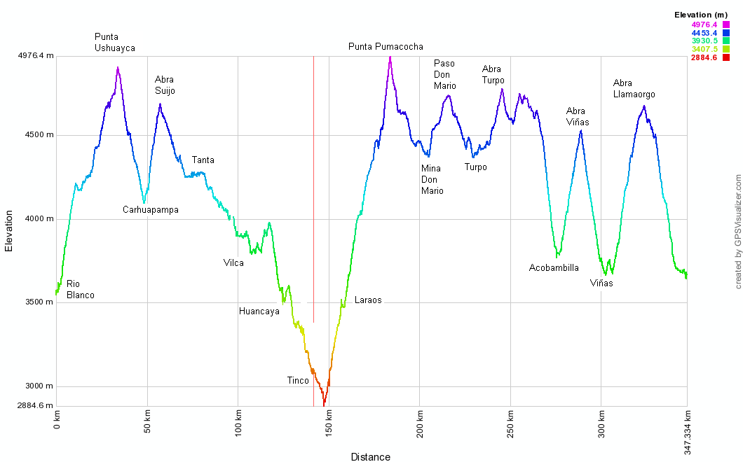
Stats – Carretera Central to Huancavelica

6 days
354km (23km paved)
8,700m climbed
7 x 4000m passes

12 Chocolate bars, 950g of pasta, 4.5l of pop each.


Climbing to Yuracmayo

After leaving the traffic madness on the Carretera Central, we camp at a fish farm. It’s one of hundreds in these parts – most lakes have a trout farm – and the freshly caught fish is a delicious treat. In the morning comes the long climb to 4930m Punta Ushuayca. It’s a lovely quiet road, and we’re left to weave all over it as we please. Which is just as we like it.

Nearing Punta Ushuayca

Nearing Punta Ushuayca the road steepens and the surface goes a bit muddy. Here’s a haggard looking Neil…

Punta Ushuayca (4930m)

…and here’s a knackered and slightly psychotic looking Haz.

Descending from Punta Ushuayca

At the top of the pass we meet the day’s second and last vehicle; a truck headed for Tanta. As we take photos it descends, but we soon catch it on the first hairpin. Rather than turning the corner, it has slid down it, and the front left wheel is perilously close to going over the edge. Some careful rock placement and desperate reversing later it makes the turn, only to repeat the performance a few more times before reaching the valley floor.

Full concentration needed on the climb to Punta Suija

The descent from Punta Ushuayca immediately turns into the climb to Punta Suija. Though this is a short one at just 500m, the surface is bad and requires full concentration. Haz manages to force her way pedalling to the top, while Pike’s combination of no weight at the front of his bike, and inherited poor balance means he’s left pushing some short sections. Still, as this is the only pushing required on the roads between Huaraz and Huancavelica we’re quite satisfied; we’d readied ourselves for more.

Nearing Punta Suija

Nearer the top of Punta Suija the terrain eases and we’re able to look around at all the lakes and snowy peaks (out of shot to Neil’s left) on show.

Descending from Punta Suija

The descent from the pass is on a beautiful road which leads to Tanta. On the way a 10m climb breaks us and we realise we’ve gone way into the red. A stop to eat all our remaining chocolate puts things to right.

The track along the Rio Cañete ends

After Tanta, Google Earth shows its good and bad sides. The town we’re heading for is labelled as ‘Carhuamachay’ on GE, but our requests for directions to this place draw blank looks. But we know what the village looks like – it’s at the end of a lake, by some pretty waterfalls. ‘Oh, you mean Vilca?’ And yes, we do. But, more importantly, GE marks a road from near Tanta, along the Rio Cañete straight to Vilca. Looking closely at the satellite photos revealed this doesn’t actually exist…

Riding to Vilca

…but it does give us the idea to try and bike-hike the route, avoiding a 50km detour over two passes. Usually we wouldn’t shun the possibility of going over a few high passes, but this bike-hike is just too tempting.

We become troglodytes for the night

Particularly when you get the opportunity to become troglodytes for the night. Another thing ticked off our ‘To do’ lists. We took refuge in this well-kept cave at 16:00 when a thunderstorm arrived. By 18:00 it was still going, so we pulled out our sleeping bags onto the nice insulating hay.

Nearing Vilca

The sun was out (as usual) in the morning, and we are delighted to find much of the chaquinani to Vilca is rideable.

Rounding Papacocha near Vilca

Laguna Papacocha appears, near Vilca.

Above Papacocha

And we’re able to cycle all the way round it and to the 4WD track which begins in the village.

Laguna Papacocha

The shortcut saves us a day’s riding, and Vilca is indeed as idyllic a spot as GE had implied. With an old Colonial bridge to boot, the road from town leads down the Rio Cañete valley…

The upper Rio Cañete

…which becomes a highlight of our route.

Sport Ancash's biggest hincha

Rather than a bog-standard river, it turns out to be a series of sapphire lakes, punctuated by waterfalls. Sport Ancash’s biggest fan scoffs some snacks while taking it all in.

The upper Rio Cañete

We’d never heard of the valley, but it’s known to Limeños – a couple of the villages lower down have numerous accommodation options. It’s easily accessed from the coast on a (mostly) paved road.

The Rio Cañete

The day we wrote this post we were sent an email from the Lonely Planet about the most beautiful landscapes in the world. One of them was Plitvice Lakes in Croatia, which in photos look just like Rio Cañete, only on a much smaller scale. Wikipedia says the Croatian lakes span 7km and drop 130m. We’d estimate these ones dropped about 200m over 12-15km.

Climbing to Punta Pumacocha

After dragging ourselves away from the cruise down the Rio Cañete, a downpour drenches us on the climb to Laraos. We stay in the municipal guesthouse then set off at 05:45 the next morning, hoping to beat the bad afternoon weather to the top of Punta Pumacocha.

Punta Pumacocha comes into view

It’s a spectacular climb, but near the top becomes savagely steep. Here’s Haz despairing when the pass comes into view (it’s the L of the two low points on the ridge). Only 2km away in a straight line, it’s still 450m above us – the most intimidating looking pass we’ve ever seen.

At 4800m on the climb to Punta Pumacocha

But the surface has been recently ‘cleaned’, and to our amazement it’s all rideable. At 4600m my cycle computer registers a gradient of 23% – the steepest it’s ever given in 4 years of ownership. Neil plays hare, pedalling hard for a few hundred metres then resting. Haz’s impressively slow tortoise pace sees her crawl up at 3.5kph.

On 4990m Punta Pumacocha

At noon, and after 6 hours of climbing we reach Punta Pumacocha. Our GPS says we’re at 4990m – 40m higher than the reading on Google Earth, but then the gradient on the north side is near vertical.

Beginning the descent from Punta Pumacocha

It’s a relief to have made it to the pass; the top 4km are at an AVERAGE gradient of 10.5%! Not the easiest thing to climb when you’re at nearly 5000m…

Heading for Mina Don Mario

The south side isn’t nearly as steep, but the surface is pretty awful until we reach this lake and have some lunch. Then comes a flattish section to Mina Don Mario. Fortunately there’s no one around there, so we sneak through the mine and climb to the next pass.

Who knew the Lion King was filmed in Peru?

On the way we pass the set for the Lion King. The Circle of Life rings out from the valley walls.

Onward to Mina Don Mario

Then comes a lovely section of road. The Peruvians seem pretty expert at building great roads which are never used. We love them for this.

Doh!

Then the next morning…Doh! Good job we’re carrying that roll of duct tape from Huaraz. Supported by a webbing strap, Haz is able to get her pannier to a cobbler in Huancavelica.

With the chicas in Viñas

A couple of easy passes sees us through Acobambilla and into Viñas. We have breakfast with this cheery pair in a shop, then I ask to take a photo before we continue. 30 mins later the lady on the L has finished combing and plaiting her hair, and is ready to be snapped. Some people!

New region, new candidate, same old graffiti

New region, new candidate, same old graffiti. Vote for Clodo and his maize!

Relaxing in the bike-armchair

The inevitable ‘it’s flat’ comments are muttered by a few in Viñas, but it’s a 1000m climb to Abra Llamaorgo. On the way my cycle computer records a 24% gradient… A few water purifying rests in the ‘pannier arm-chair’ are called for. Note duct tape.

Alejandro at home by Laguna Tanserecocha

At Laguna Tanserecocha we chat to Alejandro, who questions us about England, then asks which counrties are nearby. ‘France, Holland, Spain’, we answer, ‘but Europe is small so everywhere is close by.’ ‘If it’s so small,’ he replies, ‘why does it try and dominate the whole world?’ We ponder this as we continue to climb.


More weird rock formations in the Peruvian sierra

The final few metres of up before the 1000m descent to Huancavelica are gentle ones…

Descending to Huancavelica

…then after crossing Abra Llamaorgo comes the fast descent to town. To our delight, the road surface – from the moment we enter the Department of Huancavelica, to reaching the town itself 2 days later – is absolutely perfect.

Traffic

Yet still no-one uses it. 5 vehicles in 3 days. Plus a few thousand camelids…

Entering Huancavelica's Cathedral

15 continuous days of cycling and we arrive in Huancavelica. It’s small for a departmental capital, and is a charming place. Lots of old buildings around, and very little traffic on the streets. The Mayor of Huaraz could do with making a visit here and taking some notes – the settings and sizes of the two towns are quite similar, but Old Huanky seems to do a far better job with traffic, rubbish and dogs.

Vote....poo?

This one’s for Anna. Vote….poo?

Alfajores

Time to fatten up, gorging on any cakes we can find. And to our delight, they are very easy to find. Our first rest day sees us downing copious amounts of alfajores, pañuelos, pinapple pastries, churros, cookies…and anything else the pastelerias will sell us for S/.1.

IMG_1055_533x800

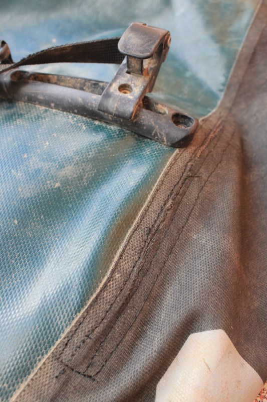
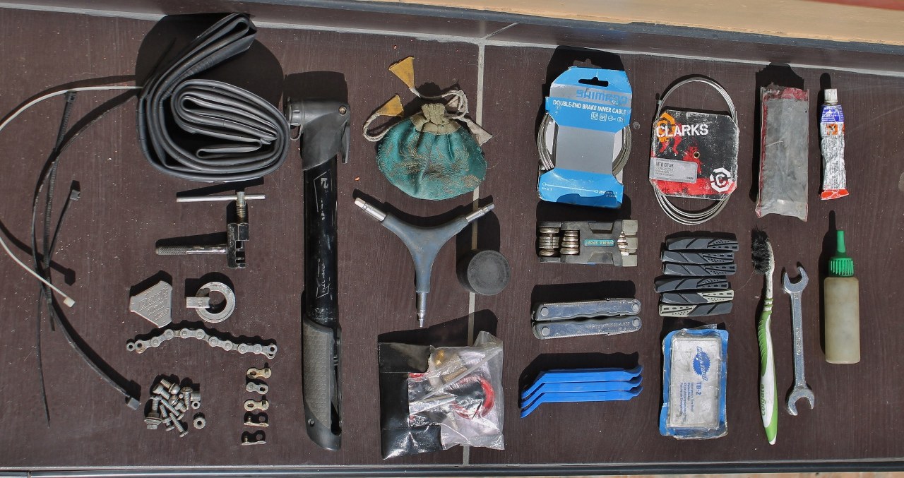
The cobbler in town seems to have done a good job…but only time will tell how it stands up to the strain of the next 700km section of our trip from Huancavelica to Abancay. Fortunately the Ortliebs are 4 years into their 5 year warranty period, so Lyon Equipment have sourced us a new set.


See our full Peru’s Great Divide: Part 2 photoset on Flickr.

[flickr_set id="72157636812490246"]


Riding Peru’s Great Divide: Part 1 – Impossibly Flat

Our route down Peru from Huaraz to Abancay was determined by one thing: taking the highest roads. From experience we knew this strategy normally provides great views, and our Google Earth planning seemed to confirm this. We would constantly be passing colourful lakes, often backdropped by snow-clad peaks. Not until a week into our journey did we realize that the roads we had chosen were continually hugging, or crossing, the Atlantic/Pacific watershed. We were riding Peru’s equivalent of the Great Divide.

On day 9 we made it to the main Lima-La Oroya highway, the Carretera Central. We were tired, but from speaking to locals, couldn’t work out why. According to half the people we chatted to all the roads we’d cycled had been flat.

We asked the shopkeeper in Yocchi what the road to Oyon was like. ‘Oh, it’s quite level, then descends to town.’ (Just the 2500m of climbing then…)

We spoke to an alpaca herder in Parquin (midway into a 2000m climb, one of the most brutal we’ve ever encountered). ‘Your bikes look good’, he said, ‘how many gears have they got?’ ’27. But in these parts we only need our lowest one.’ ‘Oh yes,’ he nodded in agreement, ‘it is so very flat round here…’

When not being convinced that cycling across Peru’s vertical geography was akin to pootling through Zeeland, we were being told the dirt roads we wished to ride were impossible by bike. ‘Wait for tomorrow’s carro. Or, better, why not cruise down the pavement to Lima and take the Pan Am down south?’

But this wasn’t an option. Riding Peru’s Great Divide was simply providing us with too much fun.

Elevation Profile

Huaraz-Rio Blanco

Stats – Conococha to Carretera Central
9 days
517km (16km paved)
12,200m climbed
11 x 4000m passes

16 Triangulo Chocolate bars, 1.2kg of pasta and 6 litres of cola each.

Climbing above Conococha

A nice easy start to our cycle. We bus to Conococha, having cycled that paving a few times before, then climb briefly to a small pass. Though we’re expecting the 3000m descent to Cañon to begin here this has to wait another day. This first day there’s an unexpected 1000m of climbing before Rajan.

Rajan, early morning

We arrive in Rajan in the pissing rain, and fears surface that we’ve left our ride south too late in the season. En route to Rajan we are warned in 2 villages that the Rajanites are a bad, unfriendly lot. Which of course turns out to be untrue. Neil did have some uncomfortable moments fending off kisses from a drunk campesino in the main square though… The graffiti is of an educational kind. ‘He who studies, triumphs!’

Descending to Cañon

In the bright morning sun we descend the 2300m to Cañon. Slicing through hillsides, the scenery is on a scale too vast to contemplate.

Still descending to Cañon

Descending into the depths of (Gran) Cañon we barely pedal for 40km. Gliding above we spot more condors than in the whole of our 5 months in the Cordillera Blanca.

Descending to Cañon

A sinuous road, weaving in and out of dry side rivulets. The descent has to accommodate numerous photo stops and takes over 2 hours.

Descending to Cañon

Number of vehicles seen in that time? Zero.

The night before it had rained cats, dogs and toffee apples.

Who ate all the other cacti?

Who ate all the other cacti? Oh, that’ll be you on the left then.

Climbing to Cajatambo

As sure as night follows day, a long descent in the Peruvian mountains means you’ll be crawling uphill for the next day (or two). 2300m down from Rajan to Cañon is followed by 3200m up to Cajatambo and Abra Pacomayo.

Home made mini-skirt

And just as climb follows descent, hanging on the wall next to the depiction of the Last Supper is sure to be a titty calendar. Or, in the more respectable establishments, a scantily clad gringa advertising some ironmongers of transport firm. But maybe the backlash has begun. Here in Cajatambo someone had covered this chica’s modesty by making a paper mini-skirt for her!

The October rains have come

The October rains have come. Fortunately the climb to Abra Pacomayo only has a few puddles, and no mud.

On Paso Pacomayo

We arrive on Paso Pacomayo early enough for the skies to be clear. It’s never long in this part of the world at this time of year before the lovely photogenic clouds turn to lightning-spitting cumulonimbus though.

Descending from Paso Pacomayo

We begin the short descent from the pass and soon reach a junction. Rather than consult our GPS which has the track Neil has planned on Google Earth, we just assume the wide road with the good surface leads to Oyon, the district capital. Turns out it doesn’t, though it takes a while for the pin to drop. We climb back up for an hour and take the muddy track to Oyon. A 2 second glance at the GPS would have seen us take this in the first place.

Laura, Haz, Karina

The blue skies turn nasty. Just in time to hide from a violent hail storm we reach Karina’s huts and shop. She turns out to be well educated and super-friendly. We put up our tent by her hut, are invited in for food and drink, and hear about how terrible she found living on the coast when she had to go there during a difficult pregnancy. Soon after Genesis, her beautiful smiling baby, was born 8 months ago she moved back up here, to the back end of la nada.


Pay your bills now!

Pay your bills now! The notice reads: to all villagers of Cashaucro, please pay your water and electric bills for 2011, 2012, 2013 by this Saturday or it’ll all be cut off! The debt collection systems in this part of the world put British Gas’ to shame.

You ain't seen me, right?

You ain’t seen me, (scoffing all the borachitos) right? These tasty, rum-laced cakes have been a staple of our Peruvian diet for months now. The moment we reach Oyon at lunchtime on day 4 we raid the cake shops.

A typical Peruvian road

The following day and we’re climbing again on a typical Peruvian road. This will be an enduring memory of our 8?10? happy months in this wonderful country.

Rapaz's Church

From Oyon we cross a 4900m pass, and outpace the rain down to Rapaz. We’d been sceptical as to the existence of the road, but it was very much there. The village turns out to be a friendly, interesting and quite large place. Unlike in Ancash, there are old buildings around – this colonial church survived the devastating 1970 earthquake. We bump into a miner whose mum lives in the street next to us in Vichay. Even in the immense Peruvian cordillera, the world is a small place.

The quebrada near Huancahuasi

From Rapaz we descend 1000m down a fascinating quebrada, towered over by these rocky ribs – hundreds of metres high. At night we camp at the Huancahuasi hot springs – nothing like a soaking in some iron and cobalt waters to reinvigorate the legs! Turns out they need reinvigorating. The following day’s climb is a beast.

Some non-threatening afternoon clouds, for a change

Some non-threatening afternoon clouds, for a change. We admire them from the thermals.

Mural in Huancahuasi

From our thermal camp we descend to Huancahuasi, take the obligatory mural shot, then continue down to Picoy, at a lowly 3000m.

This, and one moto, was the only traffic we saw all day

Then begins the 1900m climb to Abra Chucopampa. In Oyon everyone insisted there was no road over this pass to Vichaycocha. There is, and it’s brutal. Loads of sections over 10%, and in the mud at the top we were having to pause every 30 seconds to catch our breath. It’s been a while (well, our last time in Peru) since a pass has kicked our asses so badly. These sheep, and one moto, were the only traffic we saw all day.

Pastel colours near Punta Chucopampa

Near Punta Chucopampa the pastel coloured rocks give plenty to amuse the eye on our frequent rests. It’s no wonder really that mining has been a mainstay of the Peruvian economy for centuries.

Punta Chucopampa at last!

Showing the strain. After more than 8 hours of climbing we make it to the Punta Chucopampa.

Descending from Punta Chucopampa

The descent’s a good one, though equally steep. After a few kms we camp in a corral. The cloud obscures all views.

View from our campsite in Maquin

So we get a nice surprise on unzipping the tent door in the morning. Our camp in Maquin is surrounded by some lovely rock walls.

Waiting out the rain in Chungar

After another climb, this one easy, we reach the large dammed lake at Chungar. It starts raining, and we’re invited in again for some lunch with Johan’s family. They’re from the town of Huayllay (founded by Geordie settlers in the mid-18th century) but are embarking on a quieter life in Chungar. They’ve built a small house and are beginning to set up a trout farm on the lake. With about 4 neighbours and almost zero traffic on this road, we hope they’ll be happy in all the silence up here.

On Punta Fierro Cruz (4820m)

After a few hours the rains stop and we climb to the next pass, Punta Fierro Cruz.

Camp at 4700m near Punta Fierro Cruz

But it’s late, so we camp at 4700m near the top. Expected lake views never materialize as it hails and snows much of the night.

A chilly morning descending from Punta Fierro Cruz

The morning ride is somewhat chilly. And, dare we say, slightly miserable. As ever, we’re grateful for our mountaineering gloves.

Heading for the main road at Alpamarca

Then comes the only flat section of road between Huaraz and Huancavelica. All 5km of it, following a water channel. It’s muddy, then becomes muddier as we join the main Tanta-Huayllay road for a while – plenty of mine traffic on this section.

The church in Yantac

Leaving the muddy main road, there’s a lovely stretch past more lakes and some snowy peaks to Yantac. At 4650m this is the highest village we’ve encountered in Peru. One side of the Plaza is this lovely church…

Yantac's Plaza de Armas

…while the middle of the square is dominated by this. It’s difficult not to fall in love with sculptures of such undeniable beauty.

Early morning in Marcapomacocha

We continue for an hour to Marcapomacocha on a day which saw plenty of sun, and on which we were overtaken by 10 hailstorms. We’re wet and chilly again, but knocking on the Mayor’s office door leads to the keys to this pseudo-grand hotel being produced. Over and over again in Peru we’ve seen big plans not being completed; the money always seems to run out with 95% of the job done. Fortunately this isn’t the case with roads in this country, which are inevitably excellent. Almost every 1-llama-village has a rideable road to it.

Halt! Under order to shoot

The next day, our Google Earth planning reveals a weakness. After crossing a 4800m pass we descend 400m, then take a small road we know leads over an even higher pass to the main, paved Carretera Central. But after 150m of climbing we reach a barrier across the road and this sign. ‘Halt! Under order to shoot’, it reads. We continued anyway, reasoning they wouldn’t bother getting the firearms out for a couple of cyclists. Plus, we’re climbing at such great speeds (3.5-4.5kph) that we thought it unlikely that any of the security men would be good enough shots to harm us…

Being turned back in Mina Londres

But then we get to the mine buildings. These guys were willing to let us pass through, but the angry security boss arrives and tells us very firmly that this is a private road, and we must turn around now. Not sure why Neil’s looking so happy here as we lost more than half a day returning back over Punta Seis Lagos for the normal route to the Carretera Central. In the first minute on this horrible road we see more traffic than in the previous 9 days combined. Fortunately it’s a quick 30 minute downhill whizz until we turn off the paving again….

Click here to see our full Flickr Photoset for Part 1 of Peru’s Great Divide.

[flickr_set id="72157636812287854"]

Cycling Peru’s Mountain Route

As far as we know, Peru is only rivalled by Tibet when it comes to high altitude dirt road touring. Which is why it’s depressed us a few times in Huaraz when we’ve had the following conversation with cyclists going north. ‘How’s Peru been?’ ‘Ah, not much fun – the main road from Cusco’s too busy with terrible drivers and lots of roadworks.’

There is an incredibly large network of small roads crisscrossing the Peruvian sierra (unlike, say, in Argentina or Chile where there are few options) giving almost unlimited route possibilities. We’re excited about seeing what these quiet, high roads will bring.

The Plan

Having spent 2 months spiralling through southern Peru in 2010, getting no further north than Abancay. the plan this time is to head down from Huaraz to Abancay on back roads. It all depends on the weather though – those high passes won’t be much fun in the snow. We hope the weather will stay fine in October, but know we won’t be able to outrun the snows as far as Argentina, so expect to take buses from Abancay (Cusco, La Paz) to Uyuni and continue on bikes from there to Chile. Most of the time between now and February we’ll be on the Puna in Argentina, cycling to (and hopefully climbing) some big mountains. More about that later.

The Preparation

The biggest task before pedalling off into the wilderness is to plan our route in detail. Paper maps of the back roads in Peru are next to useless, and when we’re on the road in the mountains we don’t expect to find many road signs or people to help us find our way.  Where possible we’ve been spying roads on Google Earth  – most of the pictures for the Peruvian mountains have improved hugely since 2010 and are now clear enough to spot even small 4WD tracks. For the few areas where they’re not, we’ve been looking at the Peru Ministry of Transport and Communication electronic maps – the most accurate ones we know of on the web. The route planning has been Neil’s job. If we get lost, it’s his fault.

Haz has been in charge of getting our kit/tools/spares ready, and as usual on the road she’ll be in charge of repairs. First job before departure was to replace Neil’s worn back rim:

IMG_0307_533x800

With a £12 Mavic from one of Huaraz’s bike shops. Wouldn’t have gone for it at home, but there wasn’t a whole load of choice out here. That’ll teach us for forgetting to get new rims back in the UK, when we had the chance.

Then the bikes were spruced up…

IMG_0312_2136x1418

IMG_0310_2136x1396

This is Fredy, our landlord for the past 5 months, and a lovely man. Next to him is Greco – the world’s worst guard dog. When Fredy and wife Diana are away from home he’s as meek as anything. When they’re at home, Greco attacks us at every opportunity. So far the battle scoreboard reads: Greco 2 Harriet 0. Greco 1 Pike 0. Pike has tried to kick him in the head about 50 times, but the blighter ducks and dives better than Mohammed Ali. Then bites your calves when your back’s turned…  Just look at those fangs!

Tools and spares….check

IMG_0290_949x1424_533x800

IMG_0282_2136x1129_1280x677

Clothes….check

IMG_0284_1068x800

Hopefully Haz will be warm enough with all these for the route through Peru.

Camping gear….check

IMG_0298_1958x1424_1100x800

The contents of Neil’s panniers.

IMG_0300_1120x1424_629x800

And here’s what’s in his front bag/Osprey pack lid. The thermometer falls within the ‘essentials’ catergory and so gets to come on the bike to Abancay. Most clothes do not.

IMG_0293_1090x1424_612x800

Haz carries (and is in charge of using) all the cooking stuff…

Mountaineering kit……err we’ll post that to Cusco…

IMG_0292_979x1424_550x800

Neil’s mountaineering kit and front panniers/rack for the Puna. Adds a good 10kg to the bike, so it’ll be nice not having it for all the passes we’ll be crossing as we head south through Peru.

IMG_0286_1067x800

Harriet’s mountaineering kit looks surprisingly similar.


…leave this stuff here…

IMG_0271_533x800

Sadly even all our lovely maps are too heavy – we’ve photocopied the bits we need. Along with these we’re leaving behind lots of downy goodness that we hope won’t be needed on the Puna (it won’t be much below -15C, right?), as well as plenty of non-essentials like non-outdoor clothes, which we had the luxury of bringing to Huaraz.

…one final pizza…

IMG_1466_1067x800

The campesina. Enough bacon to keep us pedalling for a few weeks…

…a last pachamanca…


…and we’re ready to go!

Will check in again when we find internet, though we can’t guarantee this will be before Huancavelica – the first big town on our route, and some 850km of cycling away.

If at first you don’t get views…

Our first crossing of Punta Olimpica in May rewarded us with tantalising views such as this:

Descending from Punta Olimpica

…..try…

Then on crossing the pass in the opposite direction with Peter in August, we are treated to slightly more sun on the climb:

Cycling to the glaciers

Cycling to the glaciers on Contrahierbas. At this stage we were optimistic that we might have an enjoyable trip over the pass.

Trying to get started again in the snow

Then the weather closes in as we reach the unpaved section above the new tunnel. What had been perfectly rideable back in May turns out to be slightly less so now the authorities don’t clear the road of rock fall. Here’s Neil failing to get started – not much traction on snow when you stupidly stop in your lowest gear.

A la Punta!

Some of the 2.5km of ripio to the top is still rideable…

Pushing the steep and snowy parts to Punta Olimpica

Though not the steep corners. The only snow-free parts of the road are where the streams are running down it.

Peter enjoying a lovely summer holiday

Near the top the snow is just too deep to ride. (Here’s Pete enjoying a lovely summer holiday.)

The final push to Punta Olimpica

But eventually we make it to the top. Slightly later than expected.

The descent begins

The descent begins, and initially isn’t particularly rideable. But at least at this stage it’s 10C and we’re still warm. Then we reach the tarmac, the temperature plummets to 2C and our soaking wet feet turn to ice. We endure a miserable descent to Chacas in the driving rain. ‘This is the worst experience of my life’ says Peter through chattering teeth. Which amused us slightly, as it appeared to have replaced his previous ‘worst experience’ –  climbing Parinacota in Bolivia with us in 2010.

(To give an idea of the unlikeliness of the existence of Punta Olimpica, here’s a short transcript of a conversation we had on the way up. After climbing 15 switchbacks from the valley floor, Punta Olimpica comes into view.

Pike (always excitable at such moments): Look, Pete, the pass!

PSL: I can’t see it.

Pike: Yeah you can, the low point on the ridge over there.

PSL: I still can’t see it.

Pike: What do you mean? It’s the low point there on the skyline.

PSL (raises eyes by a few hundred vertical metres): What? You mean we’re going OVER the mountain?!

Pike: Yes! You’re going to love it!)


The next day we find some lovely dirt road cycling in Conchucos:

After a fiery argument, P Lighting and H Pike decide to go their separate ways

But not all is rosy. After a fiery argument about who copied who in the fashion department, P Lighting and H Pike decide to go their separate ways.

Sackful of maize

We stop for some pop and meet a rare gregarious villager. I snap a photo of her sack of maize. Some free ice cream and popcorn and a half hour chat later we continue to Alpabamba.

On the deserted road to Puente Llacma

On deserted roads.

Descending to the main Llacma - San Luis road

Which we have completely to ourselves.

Some cheeky lads in Cochaocro

Some cheeky lads in Cochaocro threaten to cut our throats.

Descending to AlpabambaSo we escape at speed.
Alpabamba
To Alpabamba. Not much concrete and steel on show here.
Adobe and tiles

Plenty of adobe and tiles though.

Vote Pot!

And  (surprise surprise) some political graffiti. Vote pot!

36km to somewhere

36km to…? We never found out where.

Great riding in the Callejon de Conchucos

The road descends 500m.

After a morning of gentle climbing comes a 500m descent

To the main San Luis road.

And then we climb again

Which isn’t really much busier, but brings a change in that we have a few hours of climbing.

….try again…

Then we have to hot-foot it home for Pete’s flight back to the UK, throwing our bikes on the roof of a bus from San Luis to Huaraz. We reach the new Tunel Olimpica just after dawn on a crisp and perfectly clear morning, which reveals unparalleled panoramas of the largest peaks in the Blanca. Snap decisions are made. Stop the bus! Let us out! The 2,000m cruise down to Carhuaz on two wheels is ‘the best experience’ of Pete’s life. Phew, holiday saved.

Here’s a few shots of that unforgettable descent:

The start of the 2,000m descent from Punta Olimpica to Carhuaz

The start of the 2,000m descent from Punta Olimpica to Carhuaz. Chopicalqui is the mountain we’re aiming at – Huascaran is still hidden round the corner.

Weeeeeeeeeeeeeeeeeeeeeeeee!

Weeeeeeeeeeeeeeeeeeeeeeeee!

Dominated by Huascaran

But soon Peru’s (and the tropics’) highest mountain appears, dominating the north side of the valley.

Flying down the tarmac

Flying down the tarmac. So it was worth flying out to Peru for a fortnight after all!

Punta Olimpica: there's nothing quite like it

We’ve never cycled anything quite like it…

Descending under the gaze of Huascaran Sur and Chopicalqui

900m of descent on perfect tarmac switchbacks, down to the river in Quebrada Ulta.

Zooming past Huascaran

Huascaran, looming over 2,500m above.

Some 6,000ers, some quenuales, a bike...happy days

Some 6,000ers, some quenuales, a bike, no traffic…it doesn’t get much better than this.

It's nice being able to lie down in the middle of a tarmac road

It’s nice being able to lie down in the middle of a tarmac road. There’s little traffic, and even when something does pass you get plenty of warning it’s coming – 5km away by road = a few hundred metres above/below in a straight line.

Taking photos from the storm drain

If you get bored of the middle of the road, then lying in the storm drains works too…as long as you don’t mind a few confused looks from the roadworkers.

The road to Huascaran

The road to Huascaran…

Switchbacks to Quebrada Ulta

…is long and winding…

Managed to frame the Surly in my wheel quite nicely

Haz manages to frame the Surly in my wheel quite nicely.

Rules are made to be broken

Some rules are made to be broken.

Look Mum: No Hands!

While maybe there should be rules banning certain other reckless behaviours. Look Ma: No Hands! (At 50kph…)

This scene is more common than you'd imagine in Peru

After 40km with almost no pedalling we begin to reach civilization again. Here’s a common Peruvian scene: sheep, cows, big mine company 4×4…

Another traffic jam on the way to Shilla

We hit another traffic jam on the way to Shilla. It was 09:00 and all the campesinos were heading out to their chacras for the day. Soon we’re in Carhuaz, and dismantling bikes for the taxi ride back home.